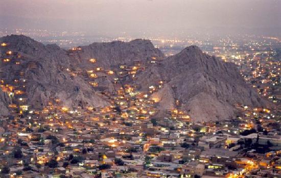
Quetta

Quetta is the provincial capital of Balochistan, Pakistan and 9th largest city of Pakistan.The city is known as the fruit garden of Pakistan,
due to the numerous fruit orchards in
and around it, and the large variety of fruits and dry fruits produced there.
The city was also known as Little Paris in the past due to its beauty and geographical location.The immediate area has long been one of pastures
and mountains, with varied plants and animals relative to the dry plains to the west. Quetta is at an average elevation of 1,680 meters (5,510 feet) above sea level,
making it Pakistan's only high-altitude major city. The population of the city is estimated to be approximately two million.
History
On joining Pakistan, Quetta was made the capital city of the newly created province of Balochistan before it was combined with other Balochi
princely states (Kalat, Makran, Lasbela and Kharan) to form the Baloch province. Quetta remained the capital of the province until 1959 when the provincial
system was abolished under Ayub Khan.
After the 1971 war, the provincial system was re-instated, and Quetta was once again made capital of Balochistan.
Education
- University of Balochistan.
- Balochistan University of Information Technology, Engineering and Management Sciences (BUITEMS)
- Sardar Bahadur Khan Women's University
- Islamia High School.
- Bolan Medical College
- Balochistan Agriculture College.
- Geological Survey of Pakistan
- Balochistan Agriculture College, Quetta.
- Federal Government (FG) Degree College
- Tameer-e-Nau Public College.
- Command and Staff College
Transport
Quetta is on the western side of Pakistan and is connected to the rest of the country by a network of roads, railways and its international airport close
to its center.
At an altitude of 1,605 metres (5,266 feet) above sea level, Quetta Airport is the second highest airport in Pakistan. Pakistan International
Airlines has regular flights to and from the other major cities of Pakistan including Islamabad, Gwadar, Karachi, Lahore and Peshawar
Quetta Railway Station is one of the highest railway stations in Pakistan at 1,676 metres (5,499 feet) above sea level. The railway track was laid
in the 1890s during the British era to link Quetta with rest of the country. The extensive network of Pakistan Railways connects Quetta to Karachi in the south,
by a 863 km (536 mi) track, Lahore in the northeast (1,170 km or 727 miles) and Peshawar further northeast (1,587 km or 986 miles). A metalled road runs alongside the railway that
connects Quetta to Karachi via the nearby town of Sibi to Jacobabad and Rohri in the plain of the River Indus.
A track from the Iranian city of Zahedan links to Quetta via Taftan, Balochistan. Service was temporarily discontinued in 2006 due to unrest in Balochistan. Since 2008 railway service has come under attack by the Balochs, especially in the Bolan Pass area resulting in a bomb blast on the railway tracks and firing on trains.
There has been a proposal to construct a railway track that will link Gawadar to China and Gawadar with Quetta via Kalat. Although the distance from Quetta to Lahore is only 700 km (430 mi), there is no direct track on this route because of the Sulaiman Range that lies in the east of Quetta. All northeast-bound trains for Punjab or Khyber Pakhtunkhwa must first go over 350 km (220 mi) south to Rohri, Sindh (near Sukkur) before continuing north to Punjab and Khyber Pakhtunkhwa.
Quetta is connected by metalled roads to the rest of the country. A road connects it with Karachi through Mastung, Kalat, Khuzdar and Lasbela.
Other major roads are Quetta to Karachi following the Sibi, Jacobabad, Sukkur and Hyderabad route and two roads from Quetta to Lahore one (the older) via Sibi,
Sukkur, Rahim Yar Khan, Bahawalpur and Multan the other route via Khanozai, Muslimbagh Loralai, Fort Mondro, Dera Ghazi Khan and Multan. Quetta is connected
with Afghanistan through Chaman and to Iran through Mastung, Nushki, Dalbandin and Taftan.